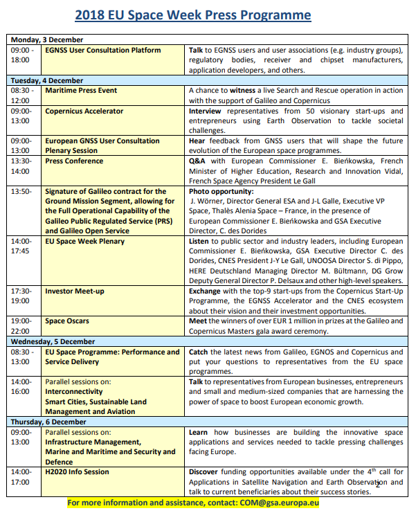
Ceit-Ik4 representing AIOSAT participated in the EU Space Week 2018 organised by GSA and ESA. It has been a great opportunity to meet other professional and projects that take advantage of the opportunities that space technologies provides. It has been a good meeting point to exchange and share ideas and future opportunities.
Satellite technologies are evolving in order to cover end-user need and this is clearly seen by the use of it in several different sectors. Galileo, EGNOS and EDAS apart from being the angular key technologies for AIOSAT are constantly being used due to their huge amount of possibilities.
These possibilities are reflected on the H2020 opportunities. EU is taking a big effort to push satellite technologies to improve our society, and it is our chance to apply to these technologies to the society by means of projects such as AIOSAT, taking care of firefighters safety, meanwhile they take care for us.participated


Copernicus, the EU’s Earth Observation programme, offers free, full and open access to satellite data used to provide services in six areas: land monitoring, marine environment monitoring, atmosphere monitoring, climate change, emergency management and security. It offers information services based on satellite Earth Observation and in situ (non-space) data.
Vast amounts of global data from satellites and from ground-based, airborne and seaborne measurement systems are being used to provide information to help service providers, public authorities and other international organisations improve the quality of life for European citizens.
The Programme is coordinated and managed by the European Commission (EC). It is implemented in partnership with the Member States, the European Space Agency (ESA), the European Organisation for the Exploitation of Meteorological Satellites (EUMETSAT). The services are provided under a delegation of the EC by the European Centre for Medium-Range Weather Forecasts (ECMWF), EU Agencies and Mercator Océan.

The European Geostationary Navigation Overlay Service (EGNOS) is Europe’s regional satellite-based augmentation system (SBAS). It is used to improve the performance of GNSSs, such as GPS and Galileo. EGNOS monitors and corrects satellite navigation signals and provides safety of life navigation services for aviation, maritime and land-based users over most of Europe.
EGNOS uses GNSS measurements taken by accurately located reference stations deployed mainly across Europe and North Africa. All measurements are transferred to a central computing centre, where differential corrections and integrity messages are calculated. These calculations are then broadcast over the covered area using geostationary satellites that serve as an augmentation, or overlay, to the original GNSS message.
The information provided by EGNOS improves the accuracy and reliability of GNSS positioning information while also providing a crucial integrity message. In addition, EGNOS transmits an accurate time signal.
The EGNOS programme is managed by the GSA since January 2014 under a delegation of the EC. The GSA contracted ESSP for the operational management, service provision and the maintenance of EGNOS.

Galileo is a European, state-of-the-art system providing improved positioning and timing information. Once fully deployed, Galileo will consist of 24 operational satellites and six in-orbit spares. Although Galileo is autonomous, it is interoperable with existing satellite navigation systems (GPS, Compass, etc.), and many devices combine two or three constellations to increase accuracy and reliability.
The first two operational Galileo satellites were launched in October 2011. Currently, there are 26 Galileo satellites in orbit (the latest launch being July 25, 2018). The Galileo constellation will be complete by 2020. Since December 2016, which marked the declaration of Galileo initial services, any mass-market device containing a Galileo-enabled chipset can use Galileo signals for positioning, navigation and timing. As of April 2018, Galileo can be found in every new type-approved vehicle sold in Europe, where it enables the eCall emergency response system. Galileo already offers its Open Service (OS), Commercial Service (CS), Public Regulated Service (PRS), and Search and Rescue Service (SAR).
As of July 1, 2017, the European GNSS Agency (GSA) has been responsible for overseeing Galileo’s operations and service provision.